
Lofoten Travel Photography Guide
Sunrise in the Lofoten Islands
Lofoten Map
Lofoten is a small group of islands on the northern coast of Norway above the arctic circle. It has been a draw for hikers and outdoor enthusiasts for years and has recently risen in popularity as a photography destination. Beautiful fjords, majestic mountains, gleaming blue lakes, and iconic fishing villages are signature elements of the region. As is typical in Scandinavian countries the different seasons offer varying photo opportunities with the angle and duration of the sun changing throughout the year, I visited in late spring which meant that there was 18 hours of daylight and 6 hours of twilight per day. This allowed for 3 hours of “Golden Hour” during sunrise and sunset but unfortunately not many opportunities or motivation for sleep. This guide will cover my advice and experiences during this window though it is recommended to research how the sunlight will affect shooting locations if you visit at different times of the year with tools such as The Photographer’s Ephemeris and Google Earth.
Hamnoy at Sunrise
Logistics
Due to the remoteness of Lofoten there are several ways of arriving. I personally flew to Oslo, the capital of Norway, then to Narvik, the largest international airport in the region, and then rented a car to drive into the islands. Cars are cheaper in the larger airports and I didn’t mind the 4 hour drive so this method made most sense to me. I booked AirBnbs along the route the first couple days to reduce the drive time. Alternatively you can fly into a closer airport such as Svolvaer from Oslo or another large city. A third option is to fly into the city of Bodo and take a ferry across the channel to Moskenes which will get you closer to the tip of the islands. For transportation renting a car is definitely recommended but because most of the roads are paved and well maintained it isn’t essential to have an SUV or 4x4.
Air Bnbs in Lofoten
Eliassen Rorbuer Prices
Lodging is plentiful in the form of AirBnbs, lodges, and hotels. There are, however, no hostels but some of the AirBnbs are run like hostels with a separate building or house behind someone’s home built for the purpose. Prices are reasonable but a little on the pricey side for a budget traveler like myself ranging from $40-$100 dollars/night depending on the time of year. Campgrounds are also available and I chose to book an AirBnb every couple days and stay at the Moskenes Campground in between. There were showers, bathrooms, and a kitchen available all for the low price of $21 dollars.
The classic lodges known as Rorbuer (the ones at Hamnoy are called Eliassen Rorbuer) are a common option for people wanting the Norwegian experience and can be booked for around the $150-$250 a night which is fine if you have the budget for it or a larger group of people. Additionally Norway has a policy called “Allemannsrett” which translates to “the everyman’s right” and basically allows you to camp anywhere in the wilderness (observing reasonable safety precautions), so if you have the right gear you can spend next to nothing on lodging. For food options there are plenty of supermarkets and a few restaurants although I didn’t visit any so I can’t personally speak to the quality and prices (I heard it’s expensive). My budget method was to purchase a cooler and stock up on canned food, sandwiches, ramen, and heat food up with a small camping stove. A final note on the logistics of visiting the Lofoten Islands is to take weather and daylight into consideration. The spring season when I visited gave me 18 hours of daylight but during the summer months this increases to 24 hours. Of course on the flipside the winter months are 24 hours of darkness. Based on these factors I hear the best time to visit for photography is around February to March because you get a decent amount of sunlight with the added bonus of photographing the Aurora Borealis. The summer months are more popular for hikers rather than photographers since the snow has thawed allowing easier access to the many hiking trails Lofoten has to offer and the weather is pleasant. In hindsight the benefit of going in the spring as I did was getting the long golden hours plus easily accessible hiking trails for those epic views and drone shots.
Locations
My location advice will cover photography spots as well as popular hiking trails in the Lofoten Islands beginning with the most famous and instagrammable one, Hamnoy.
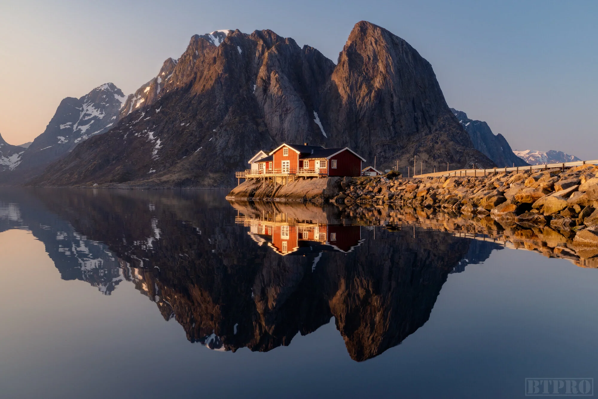
Sunrise at Hamnoy
Hamnoy/Sakrisoy
Hamnoy is a small town (really just a collection of lodges and houses) just north of Reine where the classic composition is an angle from the bridge with the red lodges in the foreground and the mountain in the background. You can park near the fish racks just across the street and walk up to the bridge. There’s a fairly tall railing so you can either shoot through the bars if you’re tripod isn’t tall enough or use a clamp mount. During peak photography season (February-March) the bridge can be completely lined with photographers although when I visited there was only one other photographer there. Depending on the time of year the light will hit this spot very differently and during the winter this makes for a great shot with the northern lights. For me a late sunrise or early sunset seemed to work best because the sun was rising at an angle from almost behind south facing Hamnoy. The classic composition is from the bridge but you can also walk down the rocks to the water’s edge and find interesting low angle compositions.
Hamnoy Map
Hamnoy from Below Bridge
Classic Yellow Cabin Shot in Sakrisoy
Just south of Hamnoy is another small town called Sakrisoy differentiated by its bright yellow lodges and cabins. There are a few compositions here if you explore the angles but the classic shot is of a small cabin lined up with a pointy mountain in the back which can be found walking up the road a little bit and shooting from the waters edge.
Lodges at Sunset in Sakrisoy

Aerial Pano of Reine at Sunrise
Reine/Reinebringen
A little further south is the largest town in the area called Reine. The main shot here is from a wooden viewing platform at the southern end of the town and makes a great sunrise shot if the sun is in the right place. I personally didn’t have any luck here. Northern lights compositions work great here as well. Drone flying is not allowed as noted in a sign by the platform.
Reine Map
Classic Composition in Reine
Frozen Lake above the Town of Reine
Reinebringen Map
Also located in the town of Reine is the famous (or infamous) Reinebringen Hike. This hike is short in distance but tall in altitude at 1469 ft and about 1.5 to 2 hrs hiking time. It’s a strenuous hike though that has been made a little easier with the addition of large stones placed by hired sherpas from Tibet. At the time I made the hike the stone stairs were halfway completed but from what I read it is set to be completed this summer (2019). To reach the beginning of the trail you can park at the Reine viewing platform and walk along the road behind the tunnel. You’ll see arrows marking the beginning of the path through a muddy forest. The trail is somewhat scattered but if you head in a general northward direction you’ll reach the beginning of the steps. After the stone steps is the steep and dangerously slippery part when there’s snowfall. At some points I felt certain I was going to slide down the edge of the mountain. Once you reach the top you’re rewarded with an amazing view of the town of Reine and the mountains in the distance. Although I made the hike at sunset I would say it’s better as a morning or sunrise hike when the sun lights the valley below.
Summit at Reinebringen Hike
If you are finding this information helpful please consider donating to the starving artist fund!
Dragon’s Eye at Uttakleiv Beach
Sunset at Uttakleiv Beach
Uttakleiv Beach/Veggen Hike
Another popular location is Uttakleiv Beach most known for its “Dragon’s Eye” composition. Uttakleiv Beach is on the northern end of one of the islands facing west making it a great sunset spot. The Dragon’s Eye is essentially a tide pool with a round algae covered stone in it creating the appearance of a large eye. It’s located at the southern end of the beach. Apart from that shot you can find many creative seascape compositions using the rocks along the shoreline.
Uttakleiv Beach Map
Dragon’s Eye at Sunset
Veggen Hike Map
There is also a hike at Uttakleiv Beach called Veggen. Veggen Hike begins as a small trail from the parking lot and works its way up a moderately steep mountain overlooking the beach. The hike is fairly easy to make and you’re rewarded with a 360 view of the beach below as well as epic mountains in the distance. This was one of my favorite hikes of Lofoten.
Sunset View from Veggen Hike
Summit at Justadtinden
Justadtinden Hike
One of the first hikes I made as I drove into Lofoten was called Justadtinden near a town called Vestvagoy. After pulling off the road into a parking lot you make your way up the trail past a building and antenna tower and continue up the mountain. This easy hike while underwhelming makes for a great introduction to the islands and after about 2.5 hours has a decent view of the valley below.
Justadtinden Hike Map
Drone Shot of the Fredvang Bridges
Fredvang Map
Fredvang/Ryten Hike
Another town worth visiting is called Fredvang which has a couple photo locations and one classic hike. On the way to Fredvang you’ll encounter two large unique looking bridges which make for a great drone shot when photographed from the town side facing the pointy mountain using the bridges as a leading line through the composition. Arriving at the town by the side of the road you’ll see a curvy river of sorts where you can find interesting horseshoe bend compositions shooting at a slightly high angle looking downwards. These are two great locations to visit for a sunrise shoot.
Fredvang Rivers at Sunrise
The popular hike in Fredvang is called Ryten which was also one of my favorite hikes. It begins at a fairly unmarked parking lot near the beginning of town where you must be sure place a parking fee in the mailbox near the house. The parking lot is on private property and the owner will definitely remind you (perhaps several times) to leave the money for her. Follow the trail from the parking lot into the mountains and across several wooden boards placed over muddy puddles. In the mountains you’ll reach a small lake and a fork in the trail. The left path leads down to Kvalvika Beach (which is also another starting point for the hike) and the right path continues up the mountain. The hike takes about 2-3 hours and once you reach the summit you’ll be rewarded with an awesome view of the beach below. This makes for a great sunset hike. At the edge of the summit is a ledge over a small platform where if composed correctly you can make it look like you’re dangling on the edge of a cliff.
Ryten Hike Map
Summit at Ryten Hike
Sand Patterns at Skagsanden Beach
Skagsanden Beach Map
Skagsanden Beach
Skagsanden Beach is a west facing beach near the town of Flakstad (a small town where one can get shots of a church and some unique looking cattle). From what I’ve seen in other photographers vlogs there are some cool shots to get when there’s snow on the distant mountains and interesting cloud formations while using patterns in the sand as foreground interest. Unfortunately when I was there I had neither so even though I got a couple shots and a time lapse at sunset I wasn’t too impressed by them. Still if you’re visiting Lofoten during the late winter months it’s worth a stop.
Aerial Sunset at Skagsanden Beach
Summit at Munkebu Hut Hike
Munkebu Hut Hike
The Munkebu Hut Hike was an interesting one in that it’s quite long and covers different types of terrain which adds to the adventure factor. It’s a 3-4 hour hike that begins in the town of Sorvagen near the last town in the islands called A. This hike is usually done in two parts, the first 3/4 hiking up to the hut where you can camp if you have gear or stay in the hut with an access key that must be picked up at the tourist office, and the last quarter to the Munken summit. Admittedly I didn’t even make it to the hut because I make a couple stops at summits on the way for drone shots and time lapses and it was getting late. Still it’s a fun hike where you go from the small town up and around the edge of a large lake, scrambling up a rocky cliff, and continuing on through snowy valleys.
Munkebu Hut Hike
Waterfall at Munkebu Hut Hike
Another Summit at Munkebu Hut Hike
There’s also a large waterfall at the beginning of the trail which I surprisingly didn’t find any mention of in photo guides and I had a lot of fun shooting long exposures and detail shots of the running water.
Unstad Beach Map
Unstad Beach
It’s surprising to know that surfing is a thriving sport this far above the arctic circle. The wetsuits are definitely thicker than normal but on the two days I visited Unstad Beach the waves were really going off and there were plenty of surfers in the water though surprisingly few for the quality of the waves. Unstad is a small town on the northwest coast making it a great sunset location with coffee shops and surf shops that rent all the gear you would need. As far as photography there isn’t much to get unless surf photography is your thing but I got some good footage for later use in my travel video.
Mountain Peaks in Lofoten
Although there are the specific well known photography locations in the Lofoten Islands the beauty of the area is that awesome compositions can be found everywhere. From the reflective lakes to mountain summits, abundant beaches and hidden waterfalls you should definitely not restrict yourself to the locations listed in this and other guides. On my last day I drove around the islands and got some epic shots and time lapses of the mountain peaks partially covered by ethereal cloud formations and many other compositions simply by keeping my eyes open and pulling off the road regularly. There is so much to be discovered in Lofoten and in Norway in general and I am certainly considering a return trip during the late winter season. You can find my travel tips video, vlog, and cinematic travel film linked below.
About
Chris Crass is a landscape photographer and travel filmmaker whose passion for creativity draws from his jetsetting lifestyle. Born in San Francisco, growing up in Dominican Republic, and now living in Miami for the last 8 years he has always sought out new experiences in far flung and exotic places and cultures. This pursuit of adventure combined with a knack for the visual arts has culminated in the founding of Boss Talk Productions and bred an artistic style that showcases locations through a flattering lens and hopefully inspires viewers to embark on their own journeys.
