Iceland Travel Photography Guide
Landscape Reflections
Reykjavik at Sunset
Iceland has become a hotspot travel destination over the last few years due to its beautiful landscapes and very instagrammable locations. What makes it great for landscape photographers is the variety and proximity of mountains, waterfalls, basalt cliffs, fjords, and other uniquely Scandinavian terrain. A photographer visiting the same locations at different times of the year will walk away with shots that bear little resemblance to each other making it a great place for repeat trips. All this goes without mention of the famous Northern Lights which alone would be a draw for those adventurous seekers of beauty.
I have visited Iceland twice, once in March and the second time in September so I got to experience lightly snowy landscapes as well as autumn colors. While both times were within the aurora season (end of Sept to March) I was only fortunate enough to get some great aurora shots on the second visit and even then I had to work for it. This will be a guide to locations I personally visited and can speak to but there’s many more known locations and with a creative eye one can find unique compositions even in what isn’t considered a hotspot. What I found from flying my drone around the mountains is there are many many unnamed and hidden waterfalls so anyone could be the discoverer of the next iconic shot.
Sunset on the Snaefellsnes Peninsula
Logistics
Getting There
In this guide I will cover the basics of food, lodging and transportation in Iceland as well as location specific photography advice. Most international flights go to the capital of Reykjavik on the southwest coast though there are two other airports in the north and east of the country.
When to Go
Iceland has every season you would expect and there are different things to do and see depending on when you go. In the summer, for example, you won’t get to see snow but you can access the Highlands which is the rugged interior of the country with many hikes and interesting things to see like the colorful hillsides and geothermal hotspots. You’ll also experience very long days and the Midnight Sun which is when the sun barely sets. In the fall you’ll get classic autumn colors and the beginning of aurora season which is end of September to March. Winters can be beautiful but harsh because snow is added to the general unpredictability of the weather and the days are very short getting to the point of 24 hours of dark in the winter solstice. If you visit in the winter it’s recommended you go at the beginning such as November or towards the end in February. Spring can be nice though you are somewhat caught between the snow melt and the greening of the landscape so the landscapes might not look strongly like either season and I would recommend either early summer or late winter instead.
Driving
Getting around Iceland is quite easy as there are paved roads that circumvent the entire outside of the island which are the inhabited regions. My recommended method would be to rent a 4x4 vehicle or camper van as opposed to taking bus tours because it will dramatically increase the flexibility of time and scheduling if you plan to shoot these locations at early or odd hours. Cars are cheapest at the airport and although most people can get by with the rental car insurance offered by their credit card company in regular countries, in Iceland it is required to get one of two levels of insurance covering gravel and dirt damage as well as wind. Iceland is a land of extremes weather and depending how far off the main roads you venture it might be a good idea to err on the side of caution. In the non winter months you probably won’t need a 4x4 for heavily snowed roads but you might want to visit the Highlands (which I haven’t done yet) and that definitely requires a heavy vehicle or taking a special lifted off road capable bus. The roads are relatively easy to drive during most of the year with the exception of winter. Ring Road somewhat circles the entire island excluding some of the east and West Fjords and Snaefellsnes Peninsula. Theoretically one could drive it in about 16 hours but that’s of course without making any stops. The most popular route taken by tourists is The Golden Circle which leaves Reykjavik and passes by a few National parks as well as the Geysir and the Gullfoss waterfall. When I was in Iceland I personally based out of a hostel in Reykjavik for a few days as I drove out to the locations in the south then moved to a hostel on the Snaefellsnes Peninsula for the next few days while I visited that area as well as a trip up to the Westfjords. Your one uncontrollable expense will be gas which runs about 7 to 8 dollars a gallon so planning the most efficient route is key although when you’re trying to make a certain location in time for an epic aurora forecast any thoughts of gas prices can be quickly forgotten. A side note here if you plan to drive around the whole island is that before deciding if you want to go clockwise or counter clockwise based on what you want to see first take a look at the weather forecast for each region in the next few days. Cloud cover varies regionally and I made the mistake of going counter clockwise by default and ended up getting caught in a storm and having to skip ahead of my itinerary just to escape the weather.
Lodging
For lodging there are options for every budget but I settled for booking hostels the first time which I ended up regretting because we had to make the drive back to base at the end of each day. The second time around I decided to rent an SUV with a roof tent and so I was able to drive around the island one and a half times staying at campgrounds along the way. As long as it isn’t too cold or windy the roof tent works great but if you decide to go more in the winter I would suggest a enclosed campervan. Campgrounds are $20-30 a day, require no reservation, and have all the facilities you need. If you plan to circumvent the entire country this is what I strongly suggest doing and it can be done in about a week making frequent stops to see the many beautiful locations. Technically you’re required to stay in a campground by law rather than stopping and camping anywhere but if you get caught in some bad weather or a long drive and there isn’t a campground nearby it’s pretty unlikely you’ll get stopped and given a ticket for rogue camping.
Food
Food is also prohibitively expensive even when eating at the gas station diners where a sandwich and soup or a slice of pizza can run you at least $15. I tend to lean to more budget oriented methods when it comes to my travels so my food habits comprised of batch cooking at the hostel combined with heating up canned and packaged food with my portable burner. Additionally I ate an obscene amount of home made sandwiches while out and about. Even with this method groceries are on the expensive side but this is still definitely the cheapest option. Now, on with the locations:
Sunrise at Gullfoss
Gullfoss Minimalist Photo
Gullfoss
Gullfoss is the furthest location on the popular Golden Circle. It’s a large waterfall that lies about an hour and 30 minute drive from Reykjavik. Although it’s a magnificent waterfall it can be difficult to shoot due to its low profile and large amount of water vapor. There are a few angles along the trail that leads to rocky outcrop near the middle of the waterfall but I only liked the wide shot I got from the top of the trail and some close up minimal long expos. This is a primarily a sunrise location and also keep in mind drones are prohibited here.
Gullfoss Map
Geysir About to Erupt
Geysir Map
Geysir
The geyser known simply as “Geysir” is an hour and a half drive from Reykjavik. Being a rather open area this is a great spot for sunrise photos. Some classic shots include getting the sun behind the spray as the geyser explodes as well as close up shots with a fast shutter to catch the water bubbling upwards. Technically the geyser that erupts is called Strokkur and it does so every 5 to 7 minutes so you have plenty of opportunities to grab a shot. Drones are prohibited here and there are signs warning against flying.
Non typical composition at Bruarfoss
Bruarfoss
Bruarfoss is a small but wide waterfall about 15 minutes from Geysir. It’s a little tricky to get to because there used to be a road that took you almost all the way there but has been closed off since my first trip to Iceland and now apparently you have to hike from the main road though its not far. The classic shot is from the bridge with the waterfall running below you but I chose to walk out on the falls and get a different perspective. This makes for a great sunset or aurora location.
Bruarfoss Map
Moody Reykjanesta Shot
Reykjanesta Map
Reykjanesta
Reykjanesta is a conveniently located set of sea stacks a little south of the main airport. On the day I visited the weather wasn’t the best so I made a moody edit of my composition. You can get some shots up by the parking lot or walk a little closer by the shore is the waves aren’t too big. Because it faces west this makes for a good sunset or aurora location. There are also geothermal mud and steam pits nearby but I wasn’t able to find a good angle of them.
Skogafoss from the Top
Skogafoss
Moving on to the southern coast of the country we find some of the most well known and visited locations. Skogafoss is an almost 200 foot tall magnificent waterfall. It lies about 2 hours from Reykjavik and is a great spot to hit at sunrise before the crowds arrive. There are some shots to be made at the base of the waterfall as well as at the top. Some classic angles are a wide shot with the rainbow as the sun reflects in the spray and also using a lens with a long focal length to shoot yourself at the base of the waterfall with the water filling the entire frame. I also found a nice composition low to the ground using the rocks and stream to lead up to the waterfall. Drones are prohibited here unfortunately. There is also another hidden waterfall nearby called Kvernufoss. Next to the museum there is a small path that leads to a river which can be followed all the way up to Kvernufoss. I’ve seen creative compositions made here using the river as a leading line but when I made the hike the wind was so strong it could practically blow you off your feet. The cool feature of this waterfall is the ability to take a photo from behind the water. Depending on the time of year I’ve seen shots of the sun setting and the golden light shining through.
Skogafoss Map
Leading Lines up to Skogafoss
Classic Skogafoss Selfie
Seljalandsfoss at Night
Seljalandsfoss BW
Seljalandsfoss Map
Seljalandsfoss
On the way to Skogafoss are a couple of other famous waterfalls worth seeing. Seljalandsfoss is a large waterfall that you can also walk behind. It’s a little more wet than Kvernufoss so taking photos is tricky and a weather sealed camera is definitely necessary. Here you can get a similar shot with the sun setting through the waterfall depending on the time of year. A short walk away is Gljufrabui, a hidden waterfall that I must admit I missed thee first time but I visited it on my second trip. From the outside you can’t really see it but there is a trail that wades through the water to reach the base of the waterfall. If you going during midday there’s usually a line of people waiting to take a photo and when you make it in be sure to bring lens clothes and a weather sealed camera because it’s soaking wet in the canyon with all the water vapor. While driving to Diamond Beach at night I noticed that Seljalandsfoss has a large light shining on it and with the proper exposure one can get a perfectly lit nighttime waterfall shot with reasonable exposure settings.
DC3 Plane Wreck at Sunset
DC3 Plane Wreck at Night
DC3 Plane Wreck
Continuing along the main road eastwards the next iconic location is the DC3 Plane Wreck also known as Solheimasandur. This is definitely something you might have seen on instagram. You will see a small parking lot with a path leading off into the distance. Depending on how many vehicles in the parking lot one can gauge how busy the site will be. When the tour buses pull up you can guarantee that getting a clean shot of the plane sitting alone will be difficult. It is obviously busier during the day but makes for a great photo at sunrise, sunset or during the auroras. Keep in mind that the walk can take up to one hour even if you try to run it which I did in order to make sunset. You won’t be able to see anything in the distance until you are upon it. If you are arriving before dawn or leaving after sunset there are reflective markers along the path to guide you. Climbing on top of the plane is allowed but I believe it’s just a matter of time before someone hurts themselves and it becomes prohibited.
DC3 Plane Wreck Map
Long Expo Seascape at Black Sand Beach
Lava Rock at Black Sand Beach
Reynisfjara
Reynisfjara is also known as Black Sand Beach due to the fact it has black volcanic sand. This beach is right before the town of Vik and has two sides to it separated by a cliff face that can sometimes be crossed if the tide is low and the waves not too powerful. Key features here are the sea stacks slightly off shore, a cave, and the beautiful basalt cliffs. On windy days this can be a challenging location to shoot as the wind will send stinging sand flying and it can be quite painful not to mention damaging to camera gear. There are opportunities for great sunset and sunrise shots here as well as drone footage. As you’re driving in you’ll pass one of the many classic Icelandic churches and while the weather wasn’t the best when I went on my second trip I got a decent moody shot. On the side of the beach next to Vik there will be mostly sharp cliff faces however there is a beach at Vik from where the sea stacks are visible. On this beach are some interesting compositions to be found using the grass that grows along the water as foreground elements.
Reynisfjara Map
Classic Cave Selfie
Church on the Road to Reynisfjara
Long Expo Sunset at Black Sand Beach
Fjalsarlon at Sunset
Fjalsarlon
The beauty of Iceland is that you could just be driving along as see something by the side of the road that makes you just have to stop and photograph it. I was on my way west when I saw the light hitting this glacier and lagoon so I stopped to shoot a couple photos and time lapses. Afterwards I looked it up and found that it was called Fjalsarlon Glacier. Easily accessible and just off the road.
Fjalsarlon Map
Long Expo at Diamond Beach
Sunrise at Jokulsarlon Lagoon
Jokularlon Lagoon Map
Jokulsarlon Lagoon/Diamond Beach
Diamond Beach is also known as Jökulsárlón and as mentioned before lies about 6 hours drive from Reykjavik. It is once you start making your way to these locations closer to the east coast of the island that it becomes more convenient to travel by campervan or find lodging nearby. This was the location I was most excited about having seen the iconic long exposure shots of the receding water on a chunk of ice at golden hour sunrise. Diamond Beach has 3 parts to it. After crossing the bridge there will be a parking lot to your left where there’s a lagoon filled with icebergs and reportedly sea lions. These icebergs break off and are washed out to sea where they break into smaller chunks and wash up on the beaches before and after the bridge. Depending on the time of year and ocean conditions you might have more luck with one verses the other but I found the beach after the bridge was less densely crowded with ice blocks and thus I was able to get my desired shot. This is definitely a sunrise location as it faces east but I made some creative shots during the aurora on the beach and over the lagoon.
Milky Way and Aurora Over Jokulsarlon Lagoon
Aurora Over Diamond Beach
Seal at Sunrise in Jokularlon Lagoon
Ice Cave Selfie
Ice Caves
Various ice cave tours leave from the Jokulsarlon Lagoon parking lot at different times of the day. I was lucky that the last day of my trip coincided with the first day of ice cave season which is usually from November to February. I booked a tour with Guide to Iceland and it cost $155. I learned that the majority of the magnificent ice cave photos you’ll see on the internet are from this large famous cave known as Crystal Cave. Unfortunately due to the melting glacier access to the Crystal Cave was closed off 2 years ago and since then the larger tour companies have resorted to finding cracks in the glacier and sort of opening them up and shaping them with chainsaws. The ice then melts and makes the pitted look on the walls. You still get the full ice cave experience and the the number of ice caves you visit will depend on what time of the season you go and how many caves they have found. Additionally from what I have seen on instagram there are locals that offer special ice cave tours and they are more resourceful in looking and finding caves and you can find some quite large caves if they are lucky. The tours take you from the parking lot to the glacier in large lifted 4x4 trucks and provide you with the necessary crampons to walk on the ice. It is not allowed neither recommended that you try to find or visit ice caves on your own.
If you are finding this information helpful please consider donating to the starving artist fund!
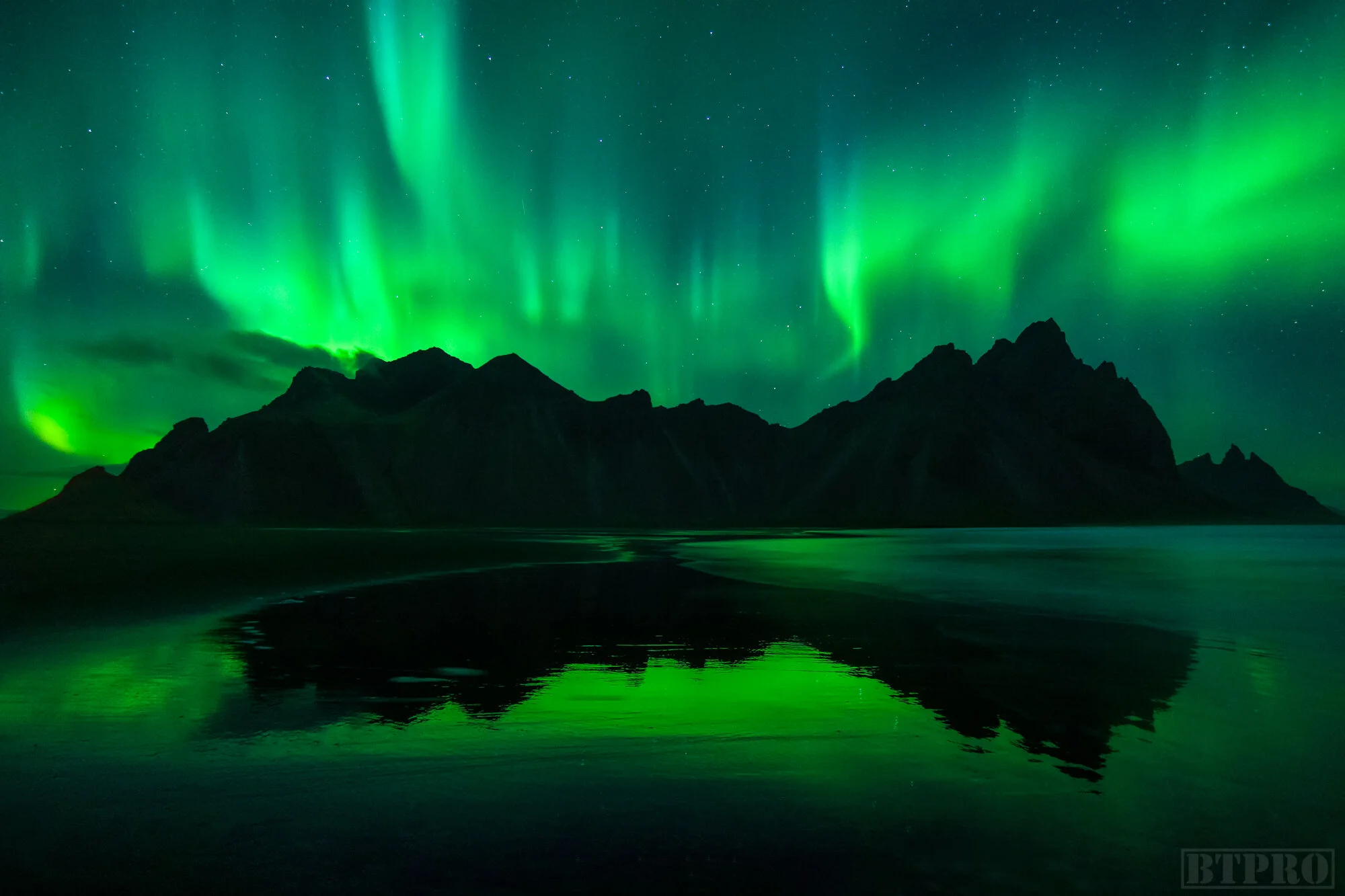
KP 5 Aurora Display at Stokksness from the beach
Classic Stokksnes Sand Dune
Self Portrait While Shooting Auroras
Stokksnes
Stokksnes is one of my favorite locations but this might partially be because it was where I got the most amazing display of northern lights on my second trip to Iceland. It’s a chain of mountains at the far end of a beach of black volcanic sand dunes with a signature sea grass type of plant growing on each one. The road to Stokksnes is right off Ring Road and before reaching the beach you will see a gate and a small gift shop that you have to enter and pay $7 for entrance. Definitely worth it. Compositions here include the classic one on the beach facing the mountains where at certain tide levels a pool of water will remain and make a perfect reflection. You can also find leading line and foreground subjects in the sand dunes themselves. The good thing is that the beach is so large you can wander around and find compositions without getting in the way of other photographers because it’s a very popular location. There’s a small movie set near the mountain base that looks like an ancient village which you can visit and apparently is planned for an upcoming movie shoot at the time of this writing.
Stokksnes Map
Long Exposure Sunset at Stokksnes
Sunrise at Eystrahorn Reflective Pool
Auroras on the Road Next to Eystrahorn
Eystrahorn Map
Eystrahorn
Continuing down the road eastwards from Stokksnes is a location popular among photographers known as Eystrahorn. It’s another chain of mountains by the beach and shots are generally taken from the peninsula at different angles. I visited this spot the same night of the epic aurora light show at Stokksnes and so most of what I got here were time lapses. There’s a lighthouse on the peninsula and this is where you park and walk down to either a reflective pool at the center or search for seascape compositions along the rocky coastline. The only shot I liked from my sunrise shoot was of the mountains in the reflective pool. This location can generally be a sunrise or sunset spot but the sun will be at different angles depending on the time of year you visit so you’ll have to consult Google Earth of Photographers Ephemeris for specifics. To be honest even though I got great aurora footage here I think the location is overrated but it might have been that my composition options were limited for the time of year I went.
Folaldafoss Long Exposure
Folaldafoss
On my second trip as I was making my first circle around the island I had run into some bad weather and was skipping ahead several locations. This waterfall I spotted from the road and it intrigued me so I had to pull over and check it out. From the parking lot there’s a short hike to to waterfall and although its not a huge one you can get right up to the waters edge and shot some interesting compositions. As mentioned it was a rainy overcast day when I stopped by so I made my photo into a moody edit but it’s still a quick little waterfall worth visiting if you’re passing by.
Folaldafoss Map
Drone Selfie at Studlagil Canyon
Studlagil Canyon by the Water’s Edge
Waterfall on the way to Studlagil Canyon
Studlagil Canyon Map
Studlagil Canyon Satellite View
Studlagil Canyon
This is a spot that has become popular in the last couple of years through social media. Apparently a few years before that it didn’t even exist because the water levels were higher and covered up all the canyons. A power plant was built upstream that diverted some of the water and thus revealed these beautiful basalt canyons. There are two sides to Studlagil Canyon, the east and the west bank. The west bank can be driven to the whole way by car and you simply look for signs to the farm Grund until you reach a parking lot and walk down to the high end of the canyon edge. The east side is the one I visited and you can make it all the way down to the waters edge for that classic instagram shot and it’s definitely worth the effort. To reach the east bank you follow the signs for the farm called Klaustursel, park at the parking lot and hike the trail for 2 to 2.5 hours until you reach a field and a path leading to the waters edge below. On the hike there you’ll see a small but nice basalt cliff waterfall that’s definitely photoworthy. There are a few angles at the east side if you explore up and down the water’s edge but be careful because it can sometimes be slippery. You’ll notice some of the photos online have a turquoise blue water while some have brown and this has something to with the water they’re diverting so in the summer and autumn it turns brown. Studlagil Canyon is very condusive to drone photography and video a well.
Classic Shot on West Side of Dettifoss
Dettifoss Map
Dettifoss Map Close
Dettifoss
Dettifoss is a large and powerful waterfall which is in fact the most voluminous waterfall in all Europe and was featured in the opening scene of the movie Prometheus. It’s located on the north of Iceland and has two sides with an hour drive to each so you’ll have to decide which one you want to shoot in advance if you’re trying to make a sunrise or sunset. The east side was the one from the movie and you can get closer to the water. I also happen to think it’s the better angle which is why I was frustrated to find out when I visited I had gone to the wrong side. It appears there’s less water vapor on that side though it might have just been the wind that day and the only downside I could tell was in shooting sunset you will be shooting into the sun but would work out great for an afterburn. The west side that I visited has opportunities for a wide shot of the massive amount of water from the bottom of the trail or a wide shot from the top of the viewing platform though in either location you will be guaranteed to get wet so have lens cloths ready. This made it frustrating for any time lapses I had set up so the only shot I took that I somewhat liked was the classic long focal length shot from the viewing platform with your subject standing near the waterfall exaggerating the size of the water for effect. I would imagine that this makes for a good sunrise and aurora location but I got unlucky with the weather and it was clouded over at night. There are a couple more waterfalls a short hike away which are part of the same river, one is called Selfoss which is accessible from the east side towards the south and Hafragilsfoss which is further up north.
Hjerfjall Sunrise Drone Shot
Hverfjall
Hverfjall is an amazing huge crate at the north of Iceland. There’s a parking lot at the base and it’s about a 25 minute hike to the rim. It’s tricky to shoot because for its size it’s not very tall but quite wide and so from the ground you best bet for getting a shot is to go vertical and get a portion of the rim with the distant mountain our hot springs in the background. The actual best angle here is with a drone from the sky and you can get pretty much the whole crater in the shot. Take caution as it can be very windy up here. Due to its altitude and 360 views you can shoot this location at sunrise, sunset, or aurora.
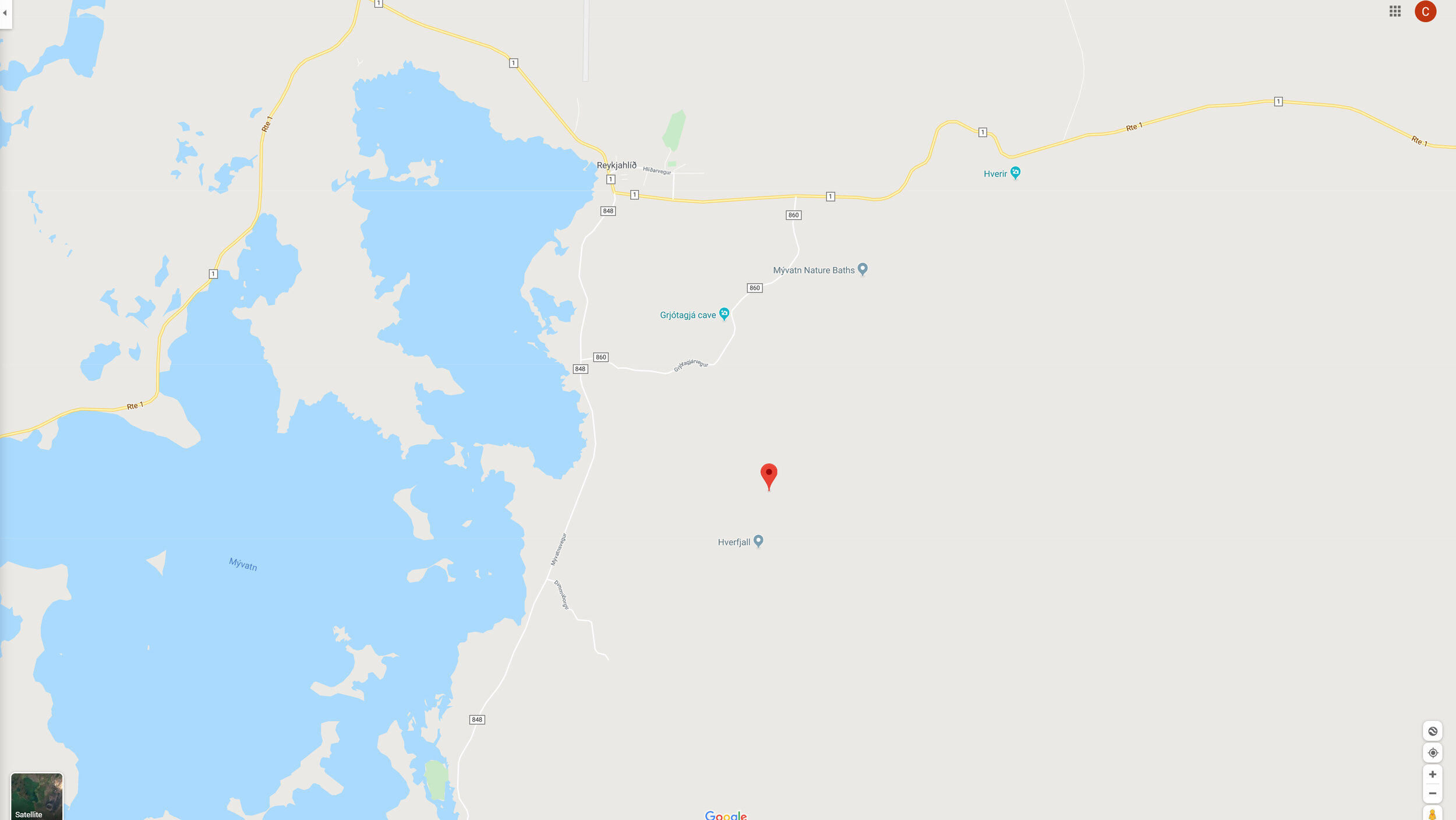
Hverfjall Map
Long Expo Sunrise at Hverfjall
Long Expo at Lone Tree
Lake Myvatn Map
Lake Myvatn/Lone Tree
This lake is right next to the crater Hverfall. There are a few locations around the lake like some sea stacks (lake stacks?) and a lava field but I shot mostly time lapses and drone of these. One location that did stand out to me was the lone tree on an island a little down the road from the crater. This made for an ideal long exposure shot as the clouds were passing over. No tricks here just walk down from the parking lot by the road and you’ll see it immediately. Makes for a great sunrise location and perhaps sunset and aurora too.
Moody Shot at Kalfshamarsviti
Kalfshamarsviti
This was a location I was very excited about because I had seen some awesome photos online and the basalt rocks surrounding the lighthouse looked like great foreground elements. Unfortunately when I visited it was cloudy and began to rain lightly. I made the best of the situation and shot several compositions one of which I turned into this moody edit. This is a highly underrated and little know location which with the right sunset can offers great shots. It’s very easy to get to as you follow the road along the peninsula and you’ll very soon see the unique light house from a distance.
Kalfshamarsviti Map
Long Expo at Hvitserkur Sunrise
Hvitserkur Map
Hvitserkur
Hvitserkur is a popular location in the north west of Iceland. It’s a rock formation by the beach which some say resembles a rhino, a troll, or a dragon. This is definitely a location worth visiting several times because not only can it be shot at sunrise and at night for auroras, the tide also changes frequently and you might have long exposure waves all the way up the beach like I did or low tide beautiful lines in the sand which make for great foreground texture. I have seen some amazing shots at this location but unfortunately I was only able to stop by once at late sunrise while escaping some bad weather from the east. To get here you leave the main road and follow a dirt road for about 20 minutes. When you reach the parking lot you can walk up to the viewing platform and hike right down to the beach. I heard in the winter when its snowed over you have to take a less steep trail away from the rock formation which doubles back and brings you down to the beach.
Arnarstapi Arch at Sunrise
Arnarstapi
My first stop on the south eastern side of the peninsula was the small town of Arnarstapi. This is a beautiful area with basalt cliffs, a troll statue, and of course the arch. There’s a platform from where you can shoot the arch as well as a small path leading to the edge of the water. I found a better angle here. This is a great sunrise location and also good for drone footage just watch out with the flocks of seagulls. Nearby there is a well known black church called Budir that makes for great long exposures or minimalist type shots. I mistakenly thought the church was in the West Fjords instead and failed to visit it. At the eastern tip you’ll find the national park Snæfellsjökull. While it seems like there is potential for many locations here I personally did only a days worth of exploring and got some drone footage of a couple of sea stacks which I was too lazy to hike to. There are definitely some interesting landscapes and also a large crater you can hike up to.
Arnarstapi Map
Sunset at Kirkjufellfoss
Sunrise at Kirkjufell
Kirkjufell Map
Kirkjufell
Moving on to the most famous landmark of the peninsula and perhaps the country itself we reach the mountain of Kirkjufell. Kirkjufell is located near the town of Grundarfjordur on the north coast. Depending on the time of year it makes for a great sunrise or sunset shot, and especially for aurora shots. This is why it’s useful to research ahead and use tools like Google maps, the Photographer’s Ephemeris, or apps like Sunseeker to see at what angle the sun will be setting. Scouting locations ahead of time also helps. Kirkjufell is one of the most visited spots and you will find many many tourists and amateur photographers lining up to the same vantage point and getting the same angle with the waterfall in the foreground. By all means get the iconic shot but realize that there are so many compositions to be found. Getting closer to the water, climbing down to the base of the waterfall, along the river bank, even the opposite side of the mountain from the adjacent peninsula are just a few ideas.
Moody Edit at Kirkjufell
Sunset by the Kirkjufell rver
Sunset at Gardar BA 64
Gardar BA 64
The final location I visited was the remote West Fjords. From my hostel in Stykkishólmur on the north coast of the peninsula this was a 4 hour and a half drive. Two locations I planned to check out were the giant majestic waterfall Dynjandi which is the largest waterfall in the West Fjords at 328 feet tall and the shipwreck Gardar BA 64. While driving up to Dynjandi I encountered increasingly snowy conditions until I reached a point where it was deeper than the height of the SUV. Given the extremely remote nature of the area I decided not to continue further at the risk of getting stuck and also to bring a shovel for next time in order to dig out snow if I found myself in a similar situation. I resigned to continue on to my next planned destination in the area and headed towards the shipwreck. The benefit of visiting these more remote areas of course is the utter lack of tourists and I had the location all to myself. From what I determined this area makes for a great sunset shot due to its facing west and had there been auroras that night it would have also been epic. After shooting the sunset I explored a few more areas nearby but since it had gotten dark decided to make the drive back. Caution should be taken when driving in this area because I made my way through dark, steep, and snowy conditions for more than four hours and it truly required ones full attention.
Gardar BA 64 Map
This concludes my guide to epic locations in the great country of Iceland. I plan to visit at least once a year because of the variety of photos that can be shot in the different seasons. Linked below is the video version of this guide, behind the scenes vlog from both my trips, as well as the cinematic travel film and mini documentary about my expedition to shoot the northern lights.
About
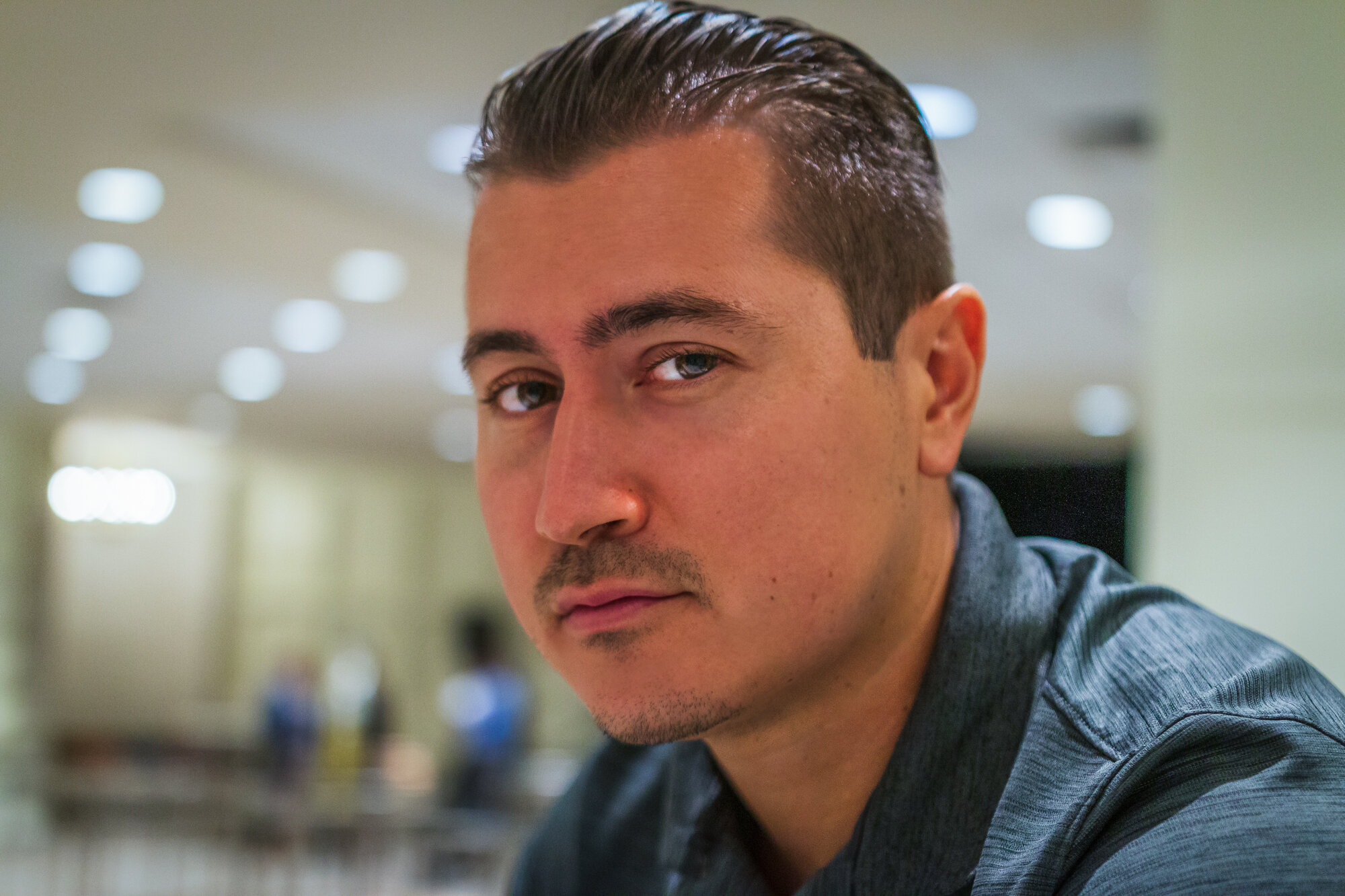
Chris Crass is a landscape photographer and travel filmmaker whose passion for creativity draws from his jetsetting lifestyle. Born in San Francisco, growing up in Dominican Republic, and now living in Miami for the last 8 years he has always sought out new experiences in far flung and exotic places and cultures. This pursuit of adventure combined with a knack for the visual arts has culminated in the founding of Boss Talk Productions and bred an artistic style that showcases locations through a flattering lens and hopefully inspires viewers to embark on their own journeys.