
Costa Rica Travel Photography Guide
Sunset at the Tamarindo Tidepools
Costa Rica is a beautiful country filled with countless National Parks and beaches worth visiting so I must admit this is by no means an exhaustive guide. I have visited the country a few times checking out the north west Guanacaste region the first time and the Caribbean and south west side just recently. Another side note, I spent part of these trips doing photography and as well as surfing and doing surf photography so there will be some advice irrelevant to the purely landscape photographer. That being said, on with the photography tips!
Logistics
Getting There
Flights are cheapest into the capital of San Jose though there are many airports throughout the whole country. Check prices in advance because logistically it might work out better to fly closer to the region you will be staying in.
When To Go
Costa Rica has two seasons, the dry season which also happens to be the high season for tourism and the wet season which is the low season. The dry season is from November to April and the west season is from May to November. Booking on the shoulder months of the high season is usually recommended for best prices and weather but if you’re visiting for the surf you’ll want to check what time of year swells hit the region you plan to visit. Also keep in mind that in different regions the exact dates of the wet and dry season might be skewed but a month of two.
Airports Map
Driving
Renting a car in Costa Rica was amazingly cheap! My first reservation worked out to $7 a day however there was some issues with my paying with a debit card and I was forced to add on full insurance coverage which bumped up the price. Had I used a credit card with its included rental car insurance then the price would’ve been that low. The second time around I got a great deal on my rate after the holidays but keep in mind that whatever price you see when you make your reservation online is missing the mandatory $15-$20 per day liability insurance which they don’t mention to you until you arrive at the rental car agency. I would suggest renting a 4x4 vehicle because the roads in Costa Rica are largely unpaved and bumpy though in some regions you can get by with a regular vehicle depending on the season for example in the wet season rivers tend to flood making some roads inaccessible.
Lodging
Lodging is also ridiculously inexpensive like anywhere in South America and there are hostels in abundance. Most hostels lack air conditioning and hot water so you will be giving up certain comforts but for prices starting from $10 it can definitely be budget friendly. AirBnbs will usually be in the mid range $30+ with hotels being the priciest option.
Food
Food is also easy on the wallet in Costa Rica. There are these classic local food restaurants called “Sodas” on almost every corner where you’ll find the typical delicious Latin American food fare such as chicken, pork, beef, rice, beans, and plantains all very prices in the $7-$10 range depending on where you go. Higher end restaurants are also available especially in the bigger cities and if you’re staying at a hostel you can of course buy food at the supermarket and batch cook.
Sunset on the Way to Monteverde
Monteverde Map
Monteverde
After a couple days of surfing and shooting in the sun I had failed to put on adequate sunscreen so in order to recover from my sunburn I headed to the cloud forests of Monteverde. From Samara it was an almost 3 hour drive most of which through pleasant small towns but from San Jose it’s only 2 and a half hours. Side note: Google maps often led me through some curious back roads during which I was glad my vehicle was 4x4 but at certain times of the year the river floods and these are impassable. During the last leg of the drive I began the uphill climb to Santa Elena the main town of Monteverde. It is said that the drive is difficult due to its unpaved uphill conditions and I must agree as I made the drive during the rain at night. Monteverde is a region famous amongst travelers seeking adventure tours like ziplining, canyoning, and tree climbing to name a few. There is a multitude of animal sanctuaries such as the iconic sloth and to be honest that is the best way to see these animals up close. I was opposed to taking such staged experiences of nature but in hindsight seeing these exotic animals in the wild is not as common to those untrained in how to look (me) so it might have been something worth doing. Nevertheless I stayed in a cheap hostel and headed into the Monteverde Reserve the next morning. I attempted a sunrise shoot but this was unfruitful as the cloudy and mountainous nature of the area prevented any such golden sunrise. The hike through the jungle can be done guided or solo after paying an entrance fee of $25. While the nature and jungle was very beautiful I must admit the most exotic creatures I saw were giant millipedes but I heard plenty of howler monkeys making their unique coughlike howl sound. I got some b roll and hiked all the way to the waterfall at the end of the trail though it left a lot to be desired especially compared to what I’ve experienced in Iceland. There is some cool drone footage to be shot of the cloudy forest. I’m not exactly sure in what areas are drones permitted or not but I flew from outside the reserve. Because of the high altitude and wet environment there are few if any mosquitoes in the region which gave me false assurance for what I was to experience later in the trip when I went to Arenal. After a day in the area I headed to my next surf destination Tamarindo.
Sunset at the Tamarindo Tidepools
Tamarindo
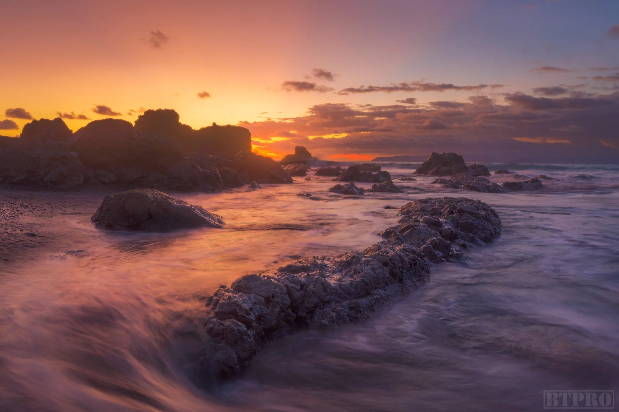
Tamarindo is a funky beach town that lies 3 hours from Monteverde. It’s most popular for its surfing, proximity to surf beaches, diving, and buzzing nightlife. I was able to book a cheap hostel here and overall the town was inexpensive. As far as photography locations go I became obsessed with these tidepools at the southern end of the beach which made for great time lapses and shots of the reflecting sunrise and sunset. The town is very safe and I felt no danger being out early in the morning or late at night with my camera gear. Tamarindo is a surf beach itself but there were not significant swells when I was there so I headed to Playa Avellana which was a mere 30 minute drive south. This is a busy beach but has multiple breaks and a fairly skilled crowd which makes for great photo opportunities. The current can be strong so caution must be taken when in the water taking photos with a water housing. Parking is supervised somewhat so I wouldn’t be too worried about leaving gear in the vehicle although preferably out of sight. I spent a couple days at this spot because of its proximity and great conditions. Another nearby beach I visited was called Playa Negra. The break is a little further out here but it is certainly less crowded and the day I went the waves were spectacular. I was going to make an attempt to take photos after a surf session but the wind had picked up and all the surfers left.
Tamarindo Map
Sunset at the Tamarindo Tidepools
Sunset at the Tamarindo Tidepools
Surfer Shredding at Playa Avellanas
If you are finding this information helpful please consider donating to the starving artist fund!
Sunset in the Mountains of Arenal
Arenal Map
Arenal
The last leg of my trip was to the Arenal Volcano National Park four hours away. On the way up the mountain you will see windmills dotting the landscape which make great subjects for drone photography. The iconic feature of this area is of course the Arenal volcano which dominates the landscape and after paying $15 at the park entrance a relatively easy hike will take you to a viewpoint from where you can sometimes see the volcano if there are no clouds. Arenal draws a similar crowd to Monteverde with its many adventure tours although it is much lower in elevation and not as cold. Arenal is an active volcano (but non erupting at the moment) and so the trails to hike up to it are closed. It was a fairly cloudy couple of days when I visited so I wasn’t able to get any clear shots of the volcano. I found a good clear vantage point by a small boat loading dock at Lago Arenal a bit before you cross the bridge to La Fortuna, the biggest town in the area. Lodging is cheap with many hostels nearby. I did a hike of the national park but as soon as I set up a time lapse at the volcano vista clouds came and it began to rain. Mosquitoes are vicious in the dense jungle areas so be sure to pack strong bug spray. There are many exotic looking and sounding birds to be seen and the leafcutter ants were entertaining to watch. In the area you’ll find several other trails and such as the hot springs, La Fortuna Waterfall, and hanging bridges which I didn’t have time to visit.
Mushroom in Los Quetzales
Mushroom in Los Quetzales
Los Quetzales
Los Quetzales is a relatively new park in Costa Rica and is about a 2 hour drive from San Jose through the mountains as long as you don’t get stuck behind a slow moving trailer truck. It’s named after a reclusive little green bird which I unfortunately didn’t see on my visit mostly due to the bad weather but it might have been difficult to see a green bird against the foliage either way. Entrance fee to the park is $10 and it’s pretty much a short hike up and down throw the forest which can be done in an hour. As with other parks in Costa Rica you can hire a guide which may have been the better option in order to see the bird but I chose to try it out on my own and all I saw that was photo worthy were this interestingly colored mushrooms. While in the area I stayed at a hostel that was a little on the pricier side in comparison to others on my trip ($30) but it was a cozy lodge and included breakfast.
Los Quetzales Map
Sunrise at Manzanillo
Long Expo Shot in Manzanillo
Birds Eye Shot of Beach in Manzanillo
Puerto Viejo Map
Puerto Viejo/Manzanillo
Puerto Viejo is a small more rural beach town about 4 hours from San Jose and is mostly known for its surf scene including the famous break of Salsa Brava. There are plenty of hostels, restaurants and a surprisingly thriving nightlife. For photography the only good location I found was actually a little further south in a smaller town called Manzanillo where there’s a wildlife refuge by the beach. Entrance fee is a donation and once you go inside and walk the trail for a few minutes you’ll come across a beach with tiny rock island and a small tree on it. I had a lot of fun at this location using rocks or coral in the foreground with the island in the back ground. I also got some good drone shots here. You’ll hear howler monkeys and if you spend time here during the day you’ll likely see them along with classic Costa Rican wildlife such as sloths, raccoons, and yellow vipers. There are a number of beached boats along the coast which make for good focal points for drone photography.
Drone Shot at Beach in Manzanillo
Beached Boat on the Coast of Manzanillo
Capuchin Monkey in Cahuita
Howler Monkey in Cahuita
Cahuita
Cahuita is the most popular national park on the Caribbean coast and about 20 minutes north of Puerto Viejo. There’s an abundant selection of wildlife here and you’re sure to see a selection of monkeys, sloths, raccoons, bats, and maybe vipers (although I didn’t) within the first hour. Entrance here is a donation just like Manzanillo and the 5 mile trail follows the coast line. It’s a very easy hike and can be done in sandals. There is a trail at the south end of the park that takes you to Puerto Vargas but if you parked up in the town of Cahuita you’ll have to double back.
Cahuita Map
Cahuita Trail Map
Sleeping Sloth in Cahuita
Bats in Cahuita
White Tip Shark at Cano Island
Uvita Map
Uvita
Uvita is small coastal town about 4 hours from San Jose. Near the town is a little National Park called Marino Ballena named after the whales that can be seen there during the right season and also the shape of the park itself resembles a whale’s tail. A short drive north is a popular surf beach known as Dominical. Accommodations were probably the cheapest here than in all my stops on this trip and I was able to find a hostel for $10. Restaurants and supermarkets are also available in the area. My primary reason for visiting Uvita was to go scuba diving with Costa Rica Dive and Surf. They take people on tours daily to Cano Island which is an hour boat ride away. Cano Island is a Biological Preserve and so it’s teeming with aquatic wildlife such as different species of fish, sea turtles, sharks, eels, manta rays, and sea horses. Costa Rica Dive and Surf takes you on two dives and includes lunch for $175. They offer great service and I strongly recommend the experience if you’re in the area.
Dive Boat at Cano Island
Cano Island Map
Sea Turtle at Cano Island
White Tip Shark at Cano Island
Long Expo Seascape at Sunset in Pavones
Sunset Drone Shot in Pavones
Seascpe in Pavones
Pavones
Pavones is a legendary surf spot about six hours drive from San Jose. It’s known as one of the longest lefts in the world when the right swell hits. On my visit I went there for the surf primarily but was pleased to find out the coastline was a seascape photographers dream. The coast line is covered in prehistoric looking rocks both large and small which, when you add the palm trees, gives the seascape a very Jurassic Park-esque look in my opinion. There’s an abundance of compositions to be found along the beach and you can shoot at sunrise or sunset but due to the direction of the sun I came away with better shots at sunset. Wildlife such as Blue and Scarlet Macaws can be found in the nearby trees and I although I didn’t see any myself I believe Howler Monkeys and Sloths as well. I did the trip in two parts since I stayed one night in Uvita for the scuba diving so it wasn’t too bad of a drive though there is where you will definitely be glad to have a 4x4 vehicle because the town of Pavones is quite rural with all dirt roads. I found the restaurants to be quite over priced probably due to the difficulty in bringing in supplies and even the super markets were meager and expensive. AirBnbs are on the higher priced tier and there are no hostels in the area.
Pavones Map
Long Expo Sunrise in Pavones
Scarlet Macaw in Pavones
This concludes my guide to Costa Rica. I was only able to check out a miniscule portion of the amazing surf beaches and exotic jungles but I am certain I will be making return trips if not only to see more of the exotic animals and of course for the surf. For additional information and footage of the beautiful landscapes check out the links below to the travel tips video, behind the scenes vlog, cinematic travel film, and surf documentary “Seeking Swells”:
About
Chris Crass is a landscape photographer and travel filmmaker whose passion for creativity draws from his jetsetting lifestyle. Born in San Francisco, growing up in Dominican Republic, and now living in Miami for the last 8 years he has always sought out new experiences in far flung and exotic places and cultures. This pursuit of adventure combined with a knack for the visual arts has culminated in the founding of Boss Talk Productions and bred an artistic style that showcases locations through a flattering lens and hopefully inspires viewers to embark on their own journeys.
